

“China’s Meteorological Satellite Programme is a Collective Effort”
- Author(s):
- Professor Xu Jianmin (CMA), Andrada Coos (WMO)

Professor Xu Jianmin has spent more than six decades watching meteorology change from a discipline of hand-drawn weather maps to one increasingly shaped by satellites, numerical weather prediction and artificial intelligence.
One of the key figures in the development of China’s FengYun meteorological satellite programme, Professor Xu played a central role in building its ground segment and transforming satellite observations into operational services. Born in August 1944, he graduated from Nanjing Meteorological College in 1965 and began his career at the Meteorological Research Institute of the China Meteorological Administration (CMA). He later worked in operational forecasting and spent two years as a visiting scientist at Colorado State University in the United States.
He became Deputy Director of the National Meteorological Center in 1983 and Director-General of the National Satellite Meteorological Center (NSMC) in 1986, later serving as Engineer General. In 1997, he was elected an Academician of the Chinese Academy of Engineering.
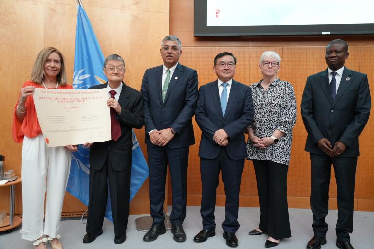
In June 2026, Professor Xu received the 70th International Meteorological Organization (IMO) Prize, the highest scientific distinction awarded by the World Meteorological Organization (WMO). Speaking to us shortly before his prize lecture, he reflected on how that journey began, what it took to build a new satellite meteorology capability and the collective action that made it possible.
What first inspired you to study meteorology?
I am colour-blind, and at that time this greatly restricted the science and engineering subjects I could apply for. Among the options open to me were mathematics, physics, mechanics and meteorology. I applied for physics and meteorology and was admitted to meteorology. So I did not begin with a great ambition to become a meteorologist. But once I started studying it, I liked it very much.
What did weather forecasting look like when you began your career?
When I first came to the meteorological office, we drew weather maps by hand. At the central meteorological office in Beijing, observations arrived on paper. People plotted the wind, temperature and height on the maps, and then we drew the contours and analysed the weather systems.
We could not simply send the completed maps to local meteorological offices. Instead, we transmitted the positions of important features as a series of latitude and longitude points, which forecasters there could connect to reconstruct the weather pattern. It was a very different way of working from today.
Was there a particular moment when China realized it needed its own meteorological satellites?
Yes, in 1969 there was a very serious ice disaster in China. Much of the telecommunications system at the time relied on lines carried on poles. Ice accumulated on the lines, they broke and communications were badly disrupted.
At the same time, China was able to receive cloud images from United States meteorological satellites. One of these images showed the cloud system associated with the disaster and was presented to Premier Zhou Enlai. He looked at it and said that China was “very much behind the world”. He then said that China should develop its own meteorological satellites. For people like me at that time, this seemed almost impossible.
Building a meteorological satellite system from very limited existing capacity must have been a huge challenge. What was your role?
A meteorological satellite mission is a very big undertaking, so it was divided into different components: the satellite itself, the instruments, launch, telemetry and the ground segment. My work was in the ground segment. Its responsibilities included mission planning, receiving and processing data, generating and distributing products and supporting research and applications.
When I became Director of NSMC in 1986, I saw my role in three main parts: administration, organizing important services for the government and users, and overcoming difficult problems in data processing.
Administration sounds simple, but it is very important. First, you have to establish the correct working objectives. To do that, you need to understand where the real difficulties are. Then you have to put capable people in the key positions. A person leading a task needs scientific knowledge, but also practical experience and the ability to cooperate with other people. If the right people are not in the right positions, the organization will not work well.
Were there technical problems that you became personally involved in solving?
One example was image navigation for the FengYun-2 geostationary satellites. We found that features in successive satellite images were not always aligned correctly. Coastlines, for example, appeared slightly displaced from their actual positions on maps.
Because geostationary satellites observe the Earth from such a great distance, even very small errors in their position or orientation can affect the accuracy of their images. When we investigated the problem with FengYun-2, we noticed that the apparent position of the centre of the Earth was shifting in a regular, wave-like pattern. This suggested that the errors were not random and could be explained mathematically.
We developed a model to describe this movement and correct the position of each image. It required a great deal of careful work to make sure every part of the model was correct. Once we solved the problem, successive FengYun-2 images aligned much more accurately and the coastlines matched their positions on maps.
How did you and your colleagues build the necessary expertise?
International cooperation helped us greatly. In the early stages of FengYun development, experts from the United States National Oceanic and Atmospheric Administration (NOAA) and its satellite service provided training to NSMC. They gave us systematic lectures, but they did not only teach science and technology. They shared their experience with us. That was extremely valuable.
We also translated important books on satellite meteorology into Chinese. Translation itself is a way of learning. When you read a book, sometimes you think you grasped its meaning. But when you try to write it down precisely in another language, you discover whether you really understood it.
Looking back, what stayed with you most from those early exchanges?
I remember something Dr John Leese, one of the U.S. experts who worked closely with us, told me. He said: “You are the director of NSMC. If you ask other people to work, but you yourself do not work, they will not listen to you. You must work hard and become their example”.
I thought he was right, and I remembered that advice. When there were difficulties, I tried to go and work on them myself.
Which milestones in the development of FengYun stand out most clearly to you?
The first was in 1988, when China launched its first FengYun polar-orbiting meteorological satellite and we received its first cloud image. After almost 20 years of work, we had reached the point where we could receive the pixel data and form the image ourselves. That was a very important moment.
But the development did not happen all at once. Our principle was to choose objectives according to what we needed and what we were capable of doing, begin with achievable objectives, make every effort to improve quality and then approach higher levels step by step.
We began with polar-orbiting satellites before moving into the much more difficult geostationary orbit. We began with visible imagery, then moved into infrared and microwave observations. As we gained experience, we could attempt more difficult things.
How far has the FengYun programme come since that first satellite?
Since then, China has now launched 23 FengYun meteorological satellites across two generations, with both polar-orbiting and geostationary satellites operating as a system.
The capabilities have also become much more advanced. The polar-orbiting satellites provide observations at different times of the day, while the geostationary satellites can now provide full-disk images every 10 minutes and, for selected areas, images as frequently as every minute. They can also observe temperature and humidity, lightning and many other features of the atmosphere and the Earth system.
FengYun is now an integral part of the WMO Integrated Global Observing System, and its data are used not only in China but by users around the world. When we began this work, I never imagined that the programme would reach this level.
How have meteorological satellites changed weather forecasting and services?
Before satellites, observations depended heavily on places where instruments and people were available. Weather balloons provide very important information, but they have to be launched from observing stations. Over much of the oceans, deserts and other sparsely populated areas, observations were much more limited.
Satellites changed that because they can observe the whole Earth. Today the vast majority of observations used by global numerical weather prediction systems come from satellites.
But obtaining an observation is only the beginning. The data have to be received, calibrated, accurately located and transformed into useful products. They then have to be used in forecasting and services.
That practical use was always important to us. We organized satellite services for forest fires, floods and environmental monitoring because observations have value when they help people make decisions.
What do you see as some of the major challenges for meteorology today, particularly with the rise of artificial intelligence?
Artificial intelligence is a powerful tool. It can analyse enormous amounts of data and identify patterns or relationships that an individual person might not notice. But finding a relationship is not the same as understanding it. Scientists still have to ask: how are these things related? What is the physical mechanism behind what we observe?
That is why I think AI and people should work together. AI can help us discover patterns, but people still have to understand what those patterns mean. There is a long, long way to go.
What does receiving the IMO Prize mean to you?
China’s meteorological satellite programme is a collective effort. In my understanding, this prize recognizes all those who have contributed to it.
A programme like FengYun depends on many people. Some build the satellites and instruments, others receive and process the data, and many more work across the different parts of the system. All of those parts have to come together.
So I see the prize as recognition by the international community of the progress made by China’s meteorological satellite programme. I am only a very small part of that story. So many people made this possible.
What advice would you give to young meteorologists and satellite scientists starting their careers today?
My advice is: work carefully and put your energy into your work. Knowledge and theory are important, but you also have to look closely at the real world and the data. Ask what is happening, why it is happening and whether your understanding can actually explain what you observe. Keep learning, keep testing what you know in practice and work carefully. That is how you make progress.
- WMO Member:
- China
- Region:
- Region II: Asia