Ocean Observations Support Hurricane Forecasts in a Warming Caribbean
- Author(s):
- Rodney Martínez (WMO), Anne-Claire Fontan (WMO, Tropical Cyclone Programme)
Every hour gained in forecasting a rapidly intensifying hurricane can translate into lives saved, infrastructure better protected and more effective emergency response. Hurricanes are not solely atmospheric phenomena. One of the greatest remaining challenges in hurricane forecasting lies beneath the ocean surface, where the storm's primary source of energy resides: ocean heat.
As the Caribbean Sea continues to warm, increasing upper-ocean heat content has become a critical driver of hurricane intensity and rapid intensification. While hurricane track forecasts have improved dramatically over recent decades, predicting changes in storm intensity remains considerably more difficult. This has placed sustained ocean observations at the centre of an emerging Earth system approach that integrates atmospheric and ocean information to strengthen forecasts, support the Early Warnings for All (EW4All) initiative and better protect vulnerable coastal communities.
For almost five decades, the World Meteorological Organization Regional Association IV (WMO RA IV) Hurricane Committee has fostered operational cooperation among National Meteorological and Hydrological Services (NMHSs) across North America, Central America and the Caribbean. The establishment of the Ocean Panel has expanded this collaboration by bringing together meteorologists, oceanographers, operational forecasting centres, research institutions and international partners, with a particular focus on improving the use of ocean observations in hurricane forecasting.
A critical gap
The first Ocean Panel, held during the 46th Session of the Hurricane Committee in 2024, was motivated by a simple yet compelling question: How can improved ocean observations enhance hurricane forecasting and coastal inundation services?
A recent review of marine and ocean services in the Caribbean highlighted a fundamental weakness in the regional observing system. Compared with atmospheric observations, upper-ocean measurements remain extremely sparse, particularly in coastal waters and Exclusive Economic Zones (EEZs), where accurate forecasts are most needed. These gaps are particularly concerning because hurricanes can develop or rapidly intensify before making landfall, placing vulnerable coastal communities at heightened risk.
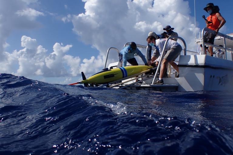
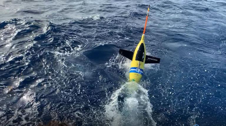
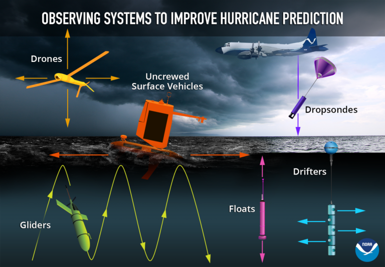
Ocean observations are therefore essential not only for research but also for operational forecasting and early warnings. As Professor Scott Glenn of Rutgers University noted, advances in observing technologies, including autonomous gliders and uncrewed systems, now make it possible to collect high-resolution ocean information that was unimaginable only a decade ago.
Different observing platforms provide complementary perspectives on ocean conditions. Argo floats measure temperature and salinity throughout the upper ocean over broad areas. Drifting buoys provide observations at the ocean surface. Autonomous gliders travel through the water column, collecting detailed information on ocean structure and can be deployed in areas of particular forecasting interest. Coastal observing networks provide additional information close to shore, where forecasts of storm surge, waves and coastal flooding become increasingly important.
Turning data into forecasts
Collecting observations is only the first step. Their greatest value is realized when they are incorporated into forecasting systems in time to influence predictions. Modern hurricane forecasting increasingly relies on coupled atmosphere-ocean models, which represent interactions between the atmosphere and ocean rather than treating them as separate systems. Real-time observations of ocean temperature and salinity can be incorporated into these models through a process known as data assimilation. In simple terms, observations help models correct their representation of the current ocean state before generating forecasts.
This is particularly important when a hurricane approaches an area where ocean conditions are poorly known. A glider, for example, can measure temperatures hundreds of metres below the surface and reveal whether a deep reservoir of warm water lies beneath the storm. Such information helps forecasting systems estimate how much energy is available to fuel the storm’s intensification, including rapid intensification.
According to Dr Michael Brennan, Director of the National Oceanic and Atmospheric Administration (NOAA) National Hurricane Center and Chair of the Hurricane Committee, hurricane intensity forecast errors have decreased by approximately 40% since 2017. Further improvements in ocean observations and their integration into forecasting systems are expected to further enhance these gains.
Staying ahead of the storm
The ultimate purpose of improving hurricane intensity forecasts is not simply to produce a more accurate estimate of wind speed. It is to provide decision-makers with more reliable information about what a storm may do and when.
Earlier identification of rapid intensification can provide emergency authorities with additional time to prepare. It can inform decisions on evacuations, shelter management, deployment of emergency personnel, protection of critical infrastructure and maritime operations. Improved understanding of ocean conditions can also enhance forecasts of related hazards such as storm surge, coastal inundation and dangerous waves.
This makes ocean observations an essential component of Early Warnings for All. Effective early warning systems depend on a chain that begins with observations and forecasting and ends with people receiving, understanding and acting on authoritative warnings.
The Caribbean illustrates the importance of this end-to-end approach. Many Small Island Developing States (SIDS) and coastal communities have limited opportunities to relocate populations and critical infrastructure away from hazards. For these communities, even modest improvements in the timeliness and reliability of warnings can make a significant difference.
Data must move as fast as the storm
Observations have little operational value if they cannot reach forecasting centres quickly. Data exchange is therefore just as important as the observing platforms themselves. The WMO System 2.0 (WIS 2.0) enables the rapid exchange of weather, climate and Earth system data using open standards and web technologies. Designed to make data easier to discover, access and share across systems and national boundaries, WIS 2.0 became operational in January 2025 and is progressively replacing the Global Telecommunication System.
For ocean observations, this means that measurements collected by one organization can be made available to forecasters and modelling centres elsewhere without unnecessary delays or barriers. However, effective data exchange also depends on the technical expertise and resources needed to operate and maintain these systems.
Sustaining the observing network
Sustained ocean observations depend on partnerships rather than individual observing systems. Argo floats, gliders, buoys, ships, coastal networks and satellites each observe different aspects of the ocean and operate across different spatial and temporal scales. The challenge lies in bringing these observations together into a coherent system capable of meeting operational forecasting needs.
This requires enduring partnerships among NMHSs, oceanographic institutions, research organizations, forecasting centres, regional organizations and international observing programmes, including the Global Ocean Observing System (GOOS). Together, these partners are working to turn sustained ocean observations into operational services that support disaster risk reduction, climate resilience and the protection of vulnerable coastal communities.
Achieving this also means moving beyond short-term research campaigns. A glider deployed as part of a research project can provide valuable information, but the greatest operational benefit is achieved when observations are collected consistently, quality-controlled, exchanged in real time and integrated into established forecasting workflows.
A road map for the future
The Ocean Panel has identified several priorities for the years ahead. First, the Caribbean requires more sustained upper-ocean observations, particularly in regions where hurricanes frequently intensify and where observations remain sparse. Second, observing platforms should be treated as components of an integrated observing system rather than as isolated projects. Combining multiple platforms provides a more comprehensive picture of ocean conditions. Third, observations must reach forecasting systems rapidly and reliably, supported by modern data-sharing infrastructure such as WIS 2.0 and by the technical capacity required to maintain it.
Fourth, stronger links are needed between research and operations so that promising technologies can transition from demonstration projects to sustained services once their operational value is established. Finally, the entire observing-to-warning chain requires long-term investment and regional cooperation. Sustained observations are infrastructure. Like weather radars, satellites and land-based observing stations, they require maintenance, expertise, coordination and predictable resources.
Through the RA IV Hurricane Committee and the Ocean Panel, meteorological and oceanographic communities are working together to strengthen hurricane forecasting across the Caribbean. Their efforts to improve ocean observations, data exchange and operational forecasting could give vulnerable coastal communities more time to prepare for dangerous storms. In a warming Caribbean, that additional time can save lives.