Global Seasonal Climate Update for May-June-July 2024
During January-March 2024, the Pacific Niño sea-surface temperature (SST) index in the eastern Pacific (Niño 1+2) returned to near-normal. The other three indices in the central Pacific were above-normal, however, they declined in their amplitude compared to the previous months. The observed SST conditions in the equatorial Pacific were characterized by a continued weakening of El Niño state. The observed Indian Ocean Dipole (IOD) was above-normal. Both the North Tropical Atlantic (NTA) and South Tropical Atlantic (STA) SST index were much above-normal and reflected widespread warmth in the tropical Atlantic. In general, the observed SST anomalies in global oceans was for a positive value1.
Above-normal sea-surface temperature anomalies in the Niño 3.4 and Niño 3 regions are predicted to decline further during May-July 2024 and transition to ENSO-neutral conditions. Farther west in the Niño 4 region, the SST anomaly is also predicted to return to near-normal condition. The IOD index is predicted to stay above-normal. In the tropical Atlantic, SSTs are predicted to be above-normal in both the northern (NTA) and the southern (STA) areas during the season. In general, the forecast for SST anomalies in global oceans is for a above-normal values.
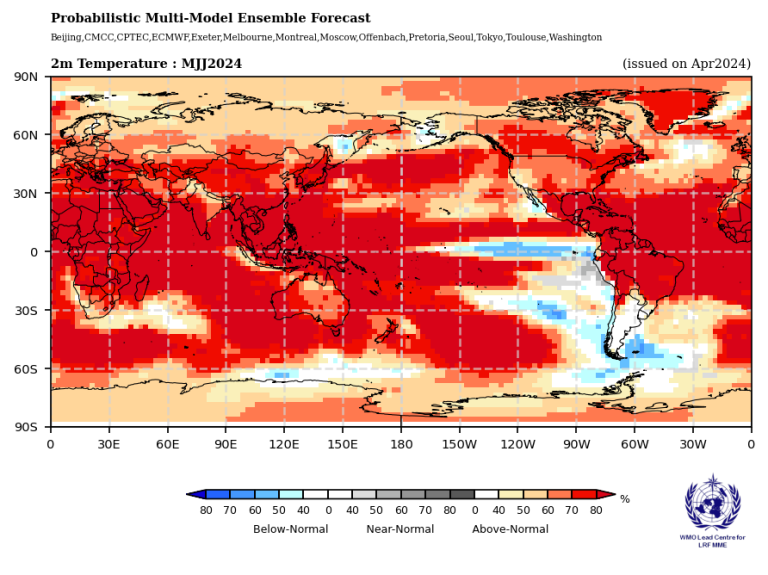
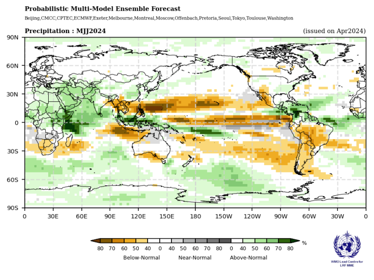
Figure 1. Probabilistic forecasts of surface air temperature and precipitation for the season May-July 2024. The tercile category with the highest forecast probability is indicated by shaded areas. The most likely category for below-normal, above-normal, and near-normal is depicted in blue, red, and grey shadings respectively for temperature, and orange, green and grey shadings respectively for precipitation. White areas indicate equal chances for all categories in both cases. The baseline period is 1993–2009.
Consistent with the prediction of above-normal SSTs over much of the global oceans, there is widespread forecast for the probability of above-normal temperatures over almost all land areas. Positive temperature anomalies are expected for nearly the entire Northern Hemisphere. The largest increases in probabilities for above-normal temperatures are generally south of 55o N over Europe, Africa, and Asia. Over much of North America probabilities for above-normal temperature are also enhanced, with the largest increase north of 40o N. Over the Caribbean and Central America, the probabilities of above-normal temperatures are strongly increased, and this area of much above-normal probabilities also extends to 30o S into South America. Extending below 30o S in South America, there is no clear indication of a forecast signal. Over most of the land areas in the Southern Hemisphere, probability for above-normal temperatures is also enhanced. Over Africa south of the equator, including Madagascar and the entire southern Indian Ocean north of 30o S, above-normal temperatures are predicted with high probabilities. Over Australia and New Zealand above-normal temperatures are predicted with moderate to high probability. Along 20o S in the Pacific Ocean, east of the Dateline, there is a band of predicted normal-to-below normal temperatures that expands southwards into the far south-eastern Pacific and continues into the southern Atlantic Ocean. Tendency for continued weakening of El Nino and return to near-normal conditions is reflected by a weak enhancement in probabilities for below-normal temperatures along a narrow band in the equatorial central and eastern Pacific.
Predictions for rainfall reflect the decaying El Niño conditions in the equatorial central and eastern Pacific, and further, an enhancement in the east-west gradient in SSTs (that are like SST gradient during a La Niña) with above- normal SSTs in the western Pacific and near-normal SSTs in the equatorial central and eastern Pacific. Weak probabilities for above-normal rainfall are predicted over a narrow band just north of the equator in the far eastern Pacific extending eastward to the southern region of Central America and crossing into the southern Caribbean where it extends north-eastward towards the oceanic regions adjacent to the southern Europe; the probabilities for above-normal rainfall have a weak or moderate enhancement. Immediately to the south and along the equator between 90o W and 150o E enhanced probability for near- to below-normal rainfall is predicted. Across most of the Pacific Ocean immediately to the north of the equatorial dry band and extending northward to about 30o N, there is enhanced probability for below-normal rainfall. This northern band of enhanced probability for below-normal rainfall extends from the eastern region of the Indian subcontinent to the western coast of Central America. Also starting from 150o E and immediately below the equator, a narrow band of probability for above-normal rainfall extends westward across the Indian Ocean to the eastern coast of Africa where it expands northward into the Arabian sea. The area of weakly enhanced probability for above-normal rainfall also covers regions of Africa above the equator and east of 10o E. Another branch of prediction for enhancement in probability for above-normal extends south-eastward from 150o E and reaches to 20o S and 130o W. In the Southern Hemisphere, the area of increase in probability for below-normal rainfall stretches across from the north-western tip of Australia westward into the Indian Ocean to about 75o E. The same region of below-normal rainfall extends eastward across the southern Pacific Ocean to reach western coast of South America. Also, in the southern hemisphere oceans between 45 - 60o S there is a band with probability of above-normal rainfall. Over most of the Arabian Peninsula a weak enhancement in the probability of above-normal rainfall is predicted. This area of modest increase in probability for above-normal rainfall also extends into southern Europe. The probability for below-normal rainfall is enhanced south of 10o S over Africa, and on the eastern side of the continent extends into oceans and over to Madagascar. Over most of North America, in general, there is no clear signal for predicted rainfall.
For more information: Global Seasonal Climate Update Archive.