El Niño expected to last at least until April 2024
The ongoing El Niño event is expected to last at least until April 2024, influencing weather patterns and contributing to a further spike in temperatures both on land and in the ocean, according to a new Update from the World Meteorological Organization.

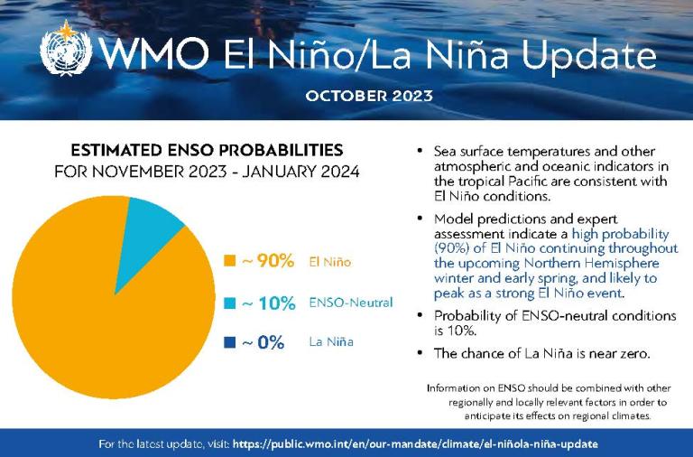
As of mid-October 2023, sea surface temperatures and other atmospheric and oceanic indicators in the central-eastern tropical Pacific are consistent with El Niño, the warm phase of El Niño/Southern Oscillation (ENSO). The El Niño developed rapidly during July-August, and reached moderate strength by September, 2023 and is likely to peak as a strong event in November - January 2024. There is a 90% likelihood it will persist throughout the upcoming northern hemisphere winter/southern hemisphere summer.
Based on historical patterns and current long-range predictions, it is anticipated it will gradually diminish during the forthcoming boreal spring, says the WMO El Niño/La Niña Update, which combines forecasts and expert guidance from around the world.
El Niño occurs on average every two to seven years, and typically last nine to 12 months. It is a naturally occurring climate pattern associated with warming of the ocean surface in the central and eastern tropical Pacific Ocean. But it takes place in the context of a climate being changed by human activities.
« El Niño impacts on global temperature typically play out in the year after its development, in this case in 2024. But as a result of record high land and sea-surface temperatures since June, the year 2023 is now on track to be the warmest year on record. Next year may be even warmer. This is clearly and unequivocally due to the contribution of the increasing concentrations of heat-trapping greenhouse gases from human activities,” said WMO Secretary-General Prof. Petteri Taalas.
“Extreme events such as heatwaves, drought, wildfires, heavy rain and floods will be enhanced in some regions, with major impacts. That is why WMO is committed to the Early Warnings For All initiative to save lives and minimize economic losses,” said Prof. Taalas.
The previous warmest year on record was 2016 due to a “double whammy” of an exceptionally strong El Niño and climate change.
Since May 2023, monthly average sea surface temperature anomalies in the central-eastern equatorial Pacific have warmed significantly, rising from about 0.5 °C above average in May, 2023) to around 1.5 °C above average in September, 2023. These estimates are relative to the 1991-2020 baseline period, using the latest version of the Optimum Interpolation Sea Surface Temperature (OISST) dataset.
The most recent forecasts and expert assessment suggest a high likelihood of continued warming in the central-eastern equatorial Pacific for at least the next four overlapping 3-month seasons: November-January, December-February, January-March, and February-April 2024.
A strong El Niño does not necessarily mean strong El Niño impacts locally. It is important to note that El Niño is not the only factor that drives global and regional climate patterns, and that the magnitudes of El Niño indicators do not directly correspond to the magnitudes of their effects. No two El Niño events are alike.