Products and services for a changing ocean
- Author(s):
- Thomas J. Cuff, Val Swail, Sarah Grimes, Christine Bassett, Johan Stander, Ian Lisk, Cyrille Honore, Wilfran Moufouma Okia, Patrick Parrish and Zhichao Wang
Maritime interests worldwide depend on timely, accurate and relevant oceanographic and marine meteorological analyses, forecasts and services, tailored to the needs of individual and community decision-making. Such services require a globally-connected and distributed effort, with strong collaboration between the oceanographic, marine meteorological and Earth science communities. Satellite applications, output from ocean and numerical weather and climate prediction models, forecasting systems and expert knowledge and experience – down to the local level – are essentials in the marine services value chain. A comprehensive understanding of the needs of users and stakeholders – shipping and other maritime industries, tourism and coastal communities – and how they interface with the range of marine products and services being provided, is also necessary.
Coastal Services and Disaster Risk Reduction
Coastal hazards – including weather-related events, such as violent storms, extreme waves, swell, storm surge, increased river discharge, and geophysical related events, such as tsunamis – cause significant human and environmental damage, killing thousands and displacing hundreds of thousands every year. Some one billion people worldwide live on low-lying land that is less than 10 metres (m) above high tide levels, and about a quarter of those live on land below the 1 m level (Kulp and Strauss, 2019). The need for timely, reliable multi-hazard early warning systems (MHEWS) to enable those people to move to safety as hazards approach cannot be underestimated.
Tropical cyclones are particularly threatening to coastal communities (see Whirling World – Tropical Cyclones and the Ocean on page 95). However, it is flooding, rather than wind, that is the primary killer when these extreme events occur. The combination of rapidly rising storm surge and freshwater flooding resulting from the heavy rains can produce severe coastal inundation. Three of the four coastal inundation events with the highest fatalities in the past 50 years have been due to storm surge. Most notable is the estimated 300 000 to 500 000 deaths due to Tropical Cyclone Bhola in Bangladesh in 1970 (Cerveny et al, 2017). Though coastal inundation is often associated with tropical cyclones, it may also occur with extratropical storms, including in ice-covered waters that can cause severe damage to coastal infrastructure.
|
|
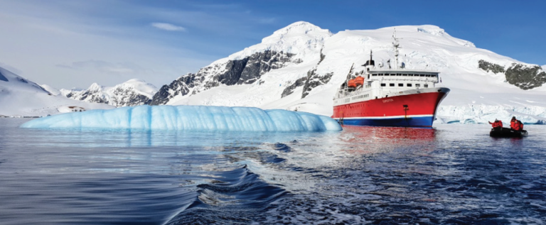
MS Expedition, Errera Channel, Antarctica. As climate change creates more opportunities for tourism in the high latitudes, so does the corresponding threat of a marine environmental emergency (Source: V. Grimes, 16 November 2018). |
WMO is implementing coastal MHEWS in communities at risk. The WMO Coastal Inundation Forecasting Demonstration Project (CIFDP), established in 2009 (Swail et al. 2019), integrated met-ocean observations, such as sea level, ocean waves, wind, pressure and precipitation with hydrological information such as river stage and discharge. In 2019, the 18th World Meteorological Congress agreed to sustain the effort as the Coastal Inundation Forecasting Initiative (CIFI) and with specific requests from Members to include tsunamis. The CIFI, along with other initiatives such as the WMO Storm Surge Watch Scheme and the Intergovernmental Oceanographic Commission (IOC) of UNESCO coordinated global tsunami early warning system will help countries to build greater capacity to provide early warnings for coastal inundation, contributing to an integrated MHEWS in support of national disaster risk reduction and management strategies and activities. WMO has been supporting this in recent years through partnership with the International Network for MHEWS (IN-MHEWS) and joint coordination of the Global MHEWS Conference. (See Oceanic Science for Services in Small-Island Developing States on page 101 and Multi-Hazard Early Warning Systems: The Coastal Inundation Forecasting Initiative on page 105)
Maritime Safety Services
The global economy relies on the safe and efficient movement of goods and passengers between ports and on commercial activities that take place on the open ocean and near coastlines. Traveling safely at sea requires information regarding natural hazards. Maritime safety services refer to activities undertaken to enhance safe ocean transit and the conduct of other activities at sea and near coasts, whether the hazards relate to navigation or to weather.
|
|
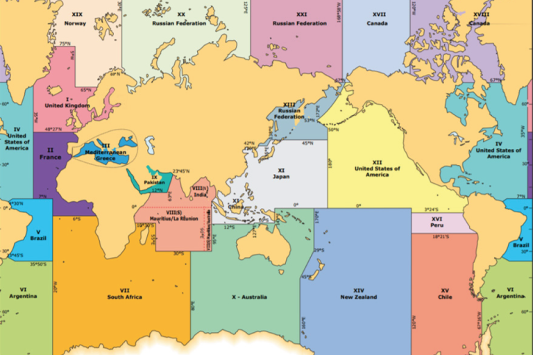
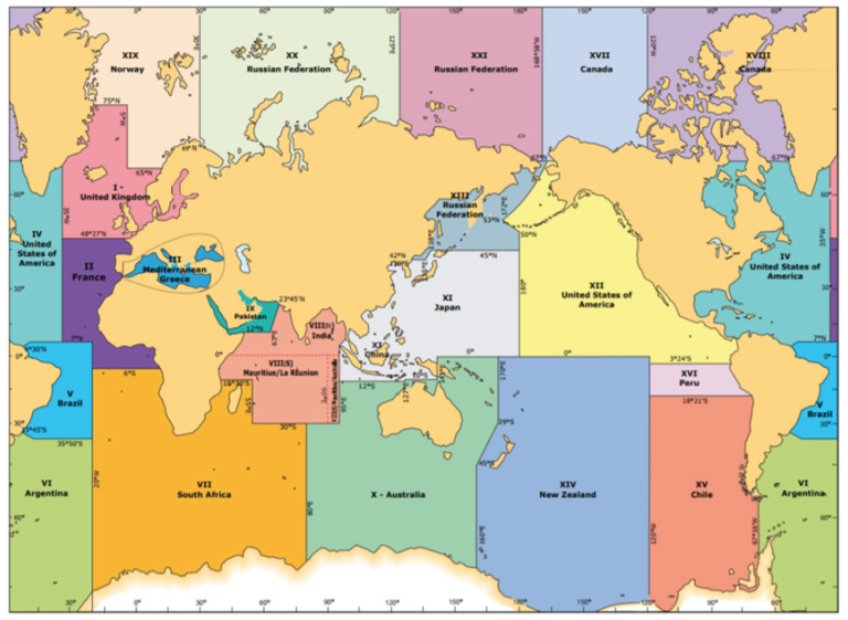
METAREA Map (Source: WMO No. 558) |
The International Maritime Organization (IMO) is the agency that maintains the UN International Convention for the Safety of Life at Sea (SOLAS), and through this they are responsible for ensuring minimum safety standards for life and ships at sea. The WMO mandate for SOLAS is to ensure Members provide relevant met-ocean maritime safety information daily for decision-making by seaborne vessels. WMO supports NHMSs in their role as the authoritative agencies for marine meteorological safety information and services.
The WMO also supports the IMO’s Global Maritime Distress and Safety System (GMDSS) through the Worldwide Metocean Information and Warning Service (WWMIWS), which coordinates the ocean through 21 defined areas, called METAREAs. NMHSs provide weather-related Maritime Safety Information (MSI) through the WWMIWS in the form of marine warning and forecast products, transmitting them via the WMO Marine Broadcast System. METAREA Coordinators are assigned by their governments to coordinate the provision of MSI for each area. They work closely with their counterpart NAVAREA Coordinators, who provide the navigational MSI through the Worldwide Navigational Warning Service (WWNWS) of the International Hydrographic Organization (IHO). This partnership between WMO, IHO and IMO, as well as the interaction between METAREA and NAVAREA coordinators with their respective national agencies, is crucial to the safety of life and property at sea.
|
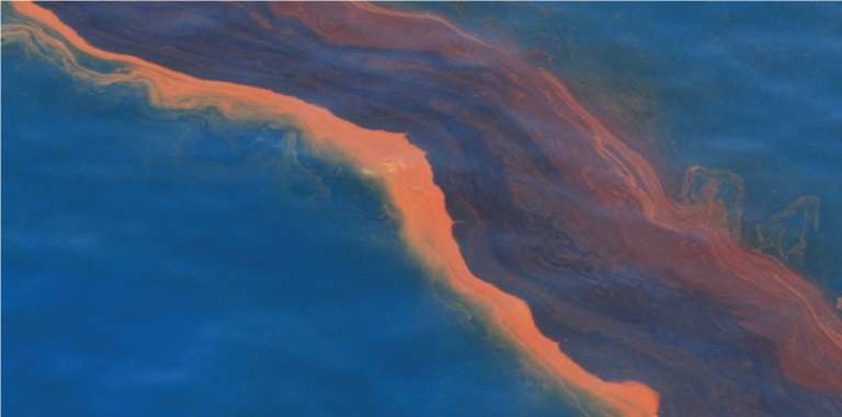
Oil visible on the surface of the Gulf of Mexico near the Deepwater Horizon oil spill on 12 May 2010 (Source: NOAA). |
Polar regions
Transiting near sea ice presents unique navigational challenges. The WMO works to coordinate standards, terminology, exchange formats and other guidance material for sea-ice and iceberg products and services. This supports navigation, coastal and offshore activities in sea-ice and iceberg conditions by monitoring sea-ice coverage in both hemispheres. In partnership with the International Ice Charting Working Group (IICWG), WMO experts provide technical advice to national Arctic and Antarctic ice forecasting centres. Through its expert network, WMO also works to support the efforts of national ice services to provide products and services in compliance with the IMO’s recently implemented Polar Code (2017).
WMO participates in the Protection of the Arctic Marine Environment (PAME) Shipping Best Practice Forum coordinated by the Arctic Council, of which it is an Observer. The Forum supports effective and practical implementation of the IMO Polar Code (2017) by publicizing information relevant to all involved in safe and environmentally sound Arctic shipping. The WMO Polar Shipping page, initiated in 2020 and directly linked to the PAME Polar Portal, acts as a single entry point for public access to practical polar information relevant to shipping and polar operators. The bi-annual WMO Arctic Consensus Statement on the Seasonal Climate Outlook and regional climate summary produced through the Arctic Climate Forums also informs shipping communities of the sea-ice outlook during polar summer and winter seasons (see Skating on Thinning Ice: Challenges in the Changing Arctic on page 86).
Marine Emergency Response
As maritime activities and operations increase, so has the need for operational services that deliver forecasts and hazard/risk mapping for marine environmental emergencies such as oil and chemical spills. WMO recognizes the need to support countries in Search and Rescue (SAR) efforts and Marine Environmental Emergency Response (MEER). SAR efforts track life and property at sea, while MEER is crucial for tracking and containing the path of environmental pollutants, such as oil and chemical spills at sea. Specialized centres for marine emergency management enhance technical capabilities, exchange diagnostic and forecast data, and provide coordination for services and information to meet requirements as defined by the International Atomic Energy Agency (IAEA) and IMO. WMO’s effort in this area is implemented through the Global Data-Processing and Forecasting System (GDPFS), which downscales forecasts from the global, to regional to national and local level. The added value of local knowledge and expertise in the final GDPFS step contributes to key SAR and MEER decision-making (see Oil spill management and salvage in the Indian Ocean on page 109).
Marine Climate Services
Marine climate services support a wide range of ocean activities – such as the design and operation of offshore and coastal facilities like drilling platforms and nuclear plants – marine transportation, fishery and regulatory activities for coastal states to ensure safety of lives and the environment. These services are also essential for establishing risk and vulnerability as a pillar of impact-based forecasting. Climate services provide the baseline for climate change detection and attribution for most marine variables, including waves, sea level, sea surface temperature, salinity, sea ice and icebergs.
Wind-generated waves play a major role in coastal sea-level dynamics and shoreline change. Future changes to deepwater wave climate (height, frequency and direction) will likely affect approximately 50% of the world's coastlines, and could drive significant changes in coastal oceanic processes and hazards (Morim et al., 2019). These issues are being addressed through the WMO-supported Coordinated Ocean Wave Climate Project (COWCLIP), the focus of which is being expanded to include global storm surge climatology.
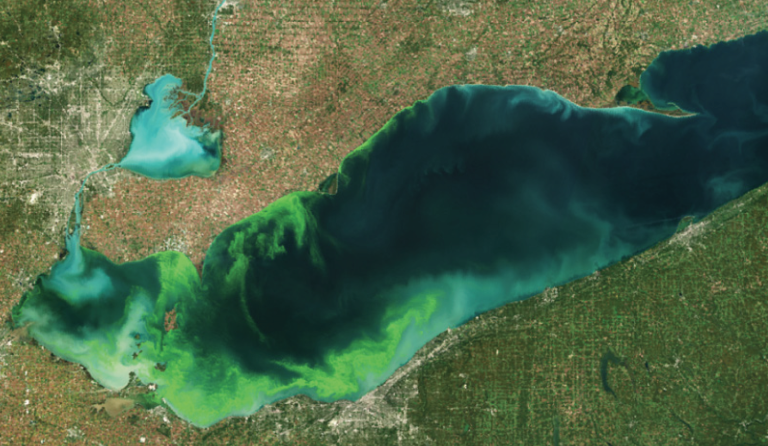
As coastal and maritime communities continue to face unprecedented challenges in response to global environmental change, there is an increasing need to better understand local, regional, and global changes in natural phenomena. Further research is needed into how climate change will impact the intensity and frequency of the El Niño Southern Oscillation (ENSO), the occurrence of marine heatwaves, especially in tropical and polar regions, the intensity and frequency of harmful algal blooms (HABs), and waves and storm surge in polar regions that were previously protected by sea-ice cover. The WMO is working to improve the provision of marine climate services that help coastal and maritime communities to better prepare for sub-seasonal and seasonal events and to develop long-range forecast products and services to address emerging threats.
Accurate climate forecasts are of utmost importance for food security, especially for fisheries. The international coordination of the collection and processing of marine and ocean data – and the preparation and delivery to users of marine and ocean climate products and services – is priority for WMO. Operational oceanographic services are providing ocean re-analyses that will ensure the availability of global data sets for fishery management decision support systems, especially related to the impacts of weather and climate change on fishery resources. In 2012, WMO and IOC of UNESCO recognized the need to provide climate services for oceanic fishery and aquaculture industries, for sub-seasonal, seasonal and long-range forecast products and services, which might also lead to enhanced observations and data transmission by fishery vessels. Liaison between meteorological services, oceanographic institutions and regional fisheries management bodies is important for establishing the requirements for marine weather and climate information. WMO will continue this work in collaboration with the co-sponsored (IOC/WMO/UNEP/ISC) Global Ocean Observing Systems (GOOS), which coordinates observations, modelling and analysis of marine and ocean variables to support research, assessments and operational ocean services worldwide.
In addition, WMO supports climate services for fisheries through Regional Climate Centres (RCCs), for example in Western South America, where ENSO has a big influence on fish populations (see Monitoring ENSO and creating ocean and climate services - the role of CIIFEN on page 88). RCCs operate across various geographical areas where climate variability and change are pronounced and where forecasts are crucial to support seasonal planning in local communities. For Arctic regions especially, where the ocean is a critical driver in the seasonal patterns, the Arctic Regional Climate Centre Network has been established and the associated Arctic Climate Outlook Forum meets twice annually bringing together providers and users of climate information across the Arctic region to agree on the coming fall and spring seasonal outlooks – with clear predictions of sea ice extent. All of this contributes to the Climate Service Information System, the operational backbone of the Global Framework for Climate Services.
Capacity Development and Marine Competencies
|
|
Harmful algal bloom on 11 July 2019, Lake Erie, North American Great Lakes. (Source: NOAA) |
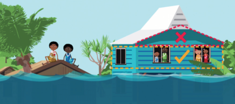
The WMO places great emphasis on building the capacity of marine services in coastal states through strong development and training programs, and in cooperation with partners such as the IMO, IHO and IOC. The Organization also strengthens public awareness and preparedness for hazards in coastal communities. This is exemplified by the 2019 WMO video on coastal inundation for the Pacific Islands, which includes education on both weather-related inundation and tsunamis and preparedness with actions to be taken.
From the late 1990s to 2015, WMO offered training workshops to NMHSs staff on Storm Surge and Wave Forecasting. The Guide to Wave Analysis and Forecasting (WMO No. 702) and the Guide to Storm Surge Forecasting (WMO No. 1076) provided content for those workshops.
WMO meets annually within a broader Joint WMO-IMO-IOC-IHO-IALA6-IMPA7 Capacity Development Panel, to discuss common training, awareness and capacity development synergies and needs, while ensuring open collaboration among partners. In addition to public awareness, through innovations in technology and a commitment to improving public weather services, WMO is bolstering the capability of meteorological services to provide better early warnings and forecasts, and to understand their customer needs for impact-based forecasting.
There are significant gaps in all regions of the world when it comes marine service delivery. To address this issue, WMO has designed a unique course to help meteorological services to self-assess their marine capabilities. The Spanish-speaking staff of NMHSs in South America were the first to participate in the April to June 2020 (3-month) online session that was supported by the Spanish Meteorological Agency (AEMET) and ended in June 2020. Ms. Alicia Cejas, METAREA Coordinator for Argentina noted that the WMO course “has been useful to focus on several service delivery aspects, the main one being to reach all users, because we will never give quality service without knowing the needs of our users”. The course will be expanded globally over the next four years. The course will also partly contribute to the endorsed Marine Weather Competency Framework for implementation in WMO Members.
|
Coastal flooding awareness cartoon helping to inform the public on what to do, and what not to do, in the event of a flood early warning (Source: WMO, 2019) |
The road ahead
As we gain a better understanding of the needs and challenges facing users and stakeholders in coastal areas and the marine community, the WMO will continue to work with partners to strengthen the capacity of Members to provide operational weather, ocean and climate forecasts, while promoting a safe, productive and healthy ocean. Several reports, most recently the WMO State of Climate Services 2020, have highlighted the need to strengthen the capacity of Members to provide authoritative early warnings for marine and terrestrial areas. Integrated multi-hazard early warning systems are a key component of climate change adaptation and of informed disaster risk reduction and management activities. The WMO Global Multi-Hazard Alert System (GMAS) framework, currently under development, will better support preparedness and response decisions for maritime and coastal communities while facilitating capacity development.
References
Cerveny et al, 2017: WMO Assessment of Weather and Climate Mortality Extremes: Lightning, Tropical Cyclones, Tornadoes, and Hail, Climate Weather and Society. Weather, Climate, and Society, 9, 487-497, doi:10.1175/WCAS-D-16-0120.1.
IHO No. 53, Joint IHO/IMO/WMO Manual on Maritime Safety Information
IMO International Code for Ships Operating in Polar Waters (entered into force, 2017)
IMO International SOLAS Convention (1974), as amended
Kulp, S.A., and B. H. StraussNew elevation data triple estimates of global vulnerability to sea-level rise and coastal flooding. Nat Commun 10, 4844 (2019). https://doi.org/10.1038/s41467-019-12808-z
Morim et al, 2019: Robustness and uncertainties in global multivariate wind-wave climate projections. Nature Climate Change, 9, 711-718, doi: 10.1038/ s41558-019-0542-5.
Swail et al (2019) Early Warnings of Coastal Inundation, WMO Bulletin Vol 68 (2)
WMO No. 558, Manual on Marine Meteorological Services (2018 edition) – map updated in 2021 for the GMDSS website
WMO (2019) Coastal Inundation - Public Awareness for the Pacific Islands Video (Youtube)
WMO (2020) State of the Climate Services Report
WMO No. 702 Guide to Wave Analysis and Forecasting (2018 edition)
WMO No. 1076 Guide to Storm Surge Forecasting (2011 edition)

