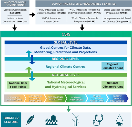
Climate Services Information System (CSIS)
The WMO Climate Services Information System (CSIS) is the principal mechanism through which information about climate – past, present and future – is routinely produced, archived, analysed, modelled, exchanged and processed.
The CSIS is the “operational core” of the Global Framework for Climate Services (GFCS), the United Nations-led initiative spearheaded by WMO to support the production and delivery of authoritative climate information products through appropriate operational mechanisms, technical standards, communication and authentication. CSIS guides the development and application of science-based climate information and services in support of decision-making in climate-sensitive sectors, such as agriculture and food security, water resources, energy, disaster risk reduction and health.
The core functions of the CSIS includes:
- Climate data,
- Climate monitoring,
- Climate prediction,
- Climate projection, and
- User-targeted climate information.
The operationalization of CSIS is organized as a three-tier network arrangement of global, regional and national providers, which carry out the CSIS functions at their respective levels. CSIS entities together ensure that climate information and products are generated, exchanged and disseminated, covering the entire space-time continuum from global to local and from past to the future:
- At global level, a range of advanced centres produce global scale climate information,
- At regional level, a network of entities regionalizes global scale climate information, and
- At national and local levels, the National Meteorological and Hydrological Services (NMHSs) and their partners are committed to providing greater added value in their national and local context to inform decision-making across a wide range of socioeconomic sectors.
In addition to generating and providing climate information and services, the CSIS facilitates interaction between the providers and users of climate services to ensure a two-way information flow through User Interface Platforms (UIPs) at the regional and national scales.
Entities that support CSIS
At global level
- Global data centres aim at collecting, managing and making available globally exchanged data of observational and computed climate variables. Global datasets underpin global and regional assessments of the state of the climate and other climate services.
- Global climate monitoring centres provide key inputs to generate climate indicators to describe the status of the global climate. These indicators are reported in flagship global products of the CSIS, such as the WMO State of the Global Climate reports.
- Global Producing Centres for Sub-seasonal Prediction (GPCs-SSP), Seasonal Prediction (GPCs-SP) and Annual to Decadal Climate Prediction (GPCs-ADCP) produce global-scale sub-seasonal, seasonal, and annual-to-decadal climate prediction products, respectively. These products are delivered to their respective Lead Centres for the generation of multi-model ensembles, which help improve the accuracy and reliability of products.
Lead Centres for Sub-seasonal Prediction Multi‑Model Ensembles (LC-SSPMME), Seasonal Prediction Multi‑Model Ensembles (LC-SPMME) and Annual to Decadal Climate Prediction (LC-ADCP) collect prediction products from relevant GPCs to generate multi-model ensemble products. They also verify both the individual GPCs’ hindcasts and the multi-model hindcasts. Lead Centres provide products - both in graphical and digital formats - including those from GPCs. Additionally, LC-SPMME and LC-ADCP provide the Global Seasonal Climate Update (GSCU) and the Global Annual to Decadal Climate Update (GADCU), respectively.
The products from GPCs and LCs are primarily used by the Regional Climate Centres (RCCs), the Regional Climate Outlook Forums (RCOFs) and NMHSs. For more information on GPCs and LCs, including their products and working mechanism, please visit WMO Integrated Processing and Prediction System (WIPPS) Technical Coordination.
- Coupled Model Intercomparison Project (CMIP) is a project of the World Climate Research Programme (WCRP) that contributes to global climate change projections. It supports national and international assessments of climate change, including those of the Intergovernmental Panel on Climate Change (IPCC).
At regional level
- Regional Climate Centres (RCCs) centres of excellence that create regional climate services and products, including seasonal prediction, regional climate assessments and regional climate datasets in support of regional and national climate activities.
- Regional Climate Outlook Forums (RCOFs) and Regional Climate Forums (RCFs) are platforms that bring together national, regional and international climate experts and stakeholders from countries in a climatologically homogenous region to provide climate predictions based on input from NMHSs, regional institutions, WMO RCCs, GPCs-SPs and other climate prediction centres.
- Coordinated Regional Downscaling Experiment (CORDEX) projects aim at advancing and coordinating the science and application of regional climate downscaling through global partnership. CORDEX is a crucial resource for RCCs to fulfill their highly recommended functions on climate change projections.
At national level
- National Climate Outlook Forums (NCOFs) and National Climate Forums (NCFs) provide opportunities for focused discussions on the significance of climate outlooks, risk information, and warnings for decision-makers in specific sectors and broader community.
- Network of National CSIS Focal Points (NCFPs)
Related news


Related events


Bangkok, Thailand
Dubai, United Arab Emirates
Dubai, United Arab Emirates
Dubai, United Arab Emirates
Dubai, United Arab Emirates
Geneva, Switzerland
Geneva, Switzerland
Geneva, Switzerland