Texas and Nepal floods highlight hazard dangers and warning challenges
Two major flood disasters in the space of a few days – in the USA and Nepal - highlight the dangers of this major hazard and the challenges in ensuring that early warnings reach those who need them.
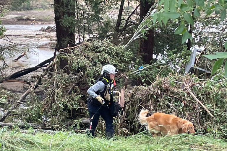
More than 100 people were confirmed dead and dozens more missing after months worth of rain fell in the space of a few hours in Texas Hill Country on 4 July. Many of the victims were young children at vacation camps swept up in the swollen river waters. WMO sends its deep condolences to everyone affected.
On the other side of the world, a devastating flood swept through Nepal’s Rasuwa district on 7 July, not due to rain but apparently to a glacial lake outburst over the border in China’s Tibet Autonomous Region. Initial reports said seven people died and 19 people were missing. It destroyed hydropower capacity, swept away an important bridge and disrupted cross-border trade.
“The disasters had different triggers, but both illustrated the threat to lives and infrastructure posed by flash floods, which are among the world’s deadliest natural hazards and claim more than 5,000 lives per year.
Accounting for approximately 85% of flooding cases, flash floods also have the highest mortality rate among different classes of flooding, including riverine and coastal. They are therefore one of the key priorities of the Early Warnings for All initiative,” said Hwirin Kim Chief of Hydrological Water Resources Services Division at WMO.
A flash flood is defined as a sudden, high-intensity flood event where the time between the triggering event (typically intense rainfall) and the onset of flooding is within a few hours. These events are characterized by rapid water level rise, high peak river discharge, and often devastating impacts on infrastructure and communities, especially in urban and mountainous areas – as was the case with Texas.
Unlike slow-onset river floods, flash floods leave very limited time for reaction, making accurate short-term forecasting and community preparedness essential. That is why WMO emphasizes both technological innovation and training in hazard forecasting, early warning dissemination, and risk communication.
Texas Hill Country Flood
The US National Weather Service issued a flash flood watch for Kerr County more than 12 hours in advance. This was upgraded to a flash flood warning about three hours ahead of time, culminating in a flash flood emergency, which was disseminated by Weather Radio, emergency management systems, and TV/radio.
But one of the challenges was that the final warnings came as people were sleeping and there were no local sirens in the camps. Floodwaters surged dramatically at about 4 a.m., with the Guadalupe river jumping 26 feet (nearly 8 meters) in 45 minutes.
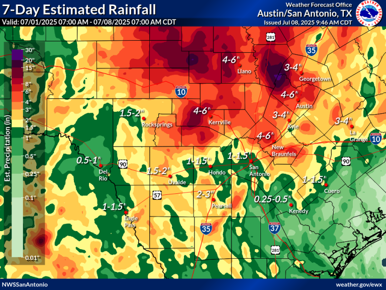
Tropical moisture from a tropical storm that struck Mexico south of Texas coupled with a storm system from Northwestern Mexico caused a mesoscale convective complex to develop over the central Texas Hill Country late on 3 to 4 July. This produced 10–18 inches (25-46 cm) with a maximum of 18 inches of rain in a few hours, rapidly overwhelming the Guadalupe River basin in Kerr County.
The steep, rocky terrain of the Hill Country caused minimal rainfall absorption, promoting rapid runoff.
China-Nepal Flood
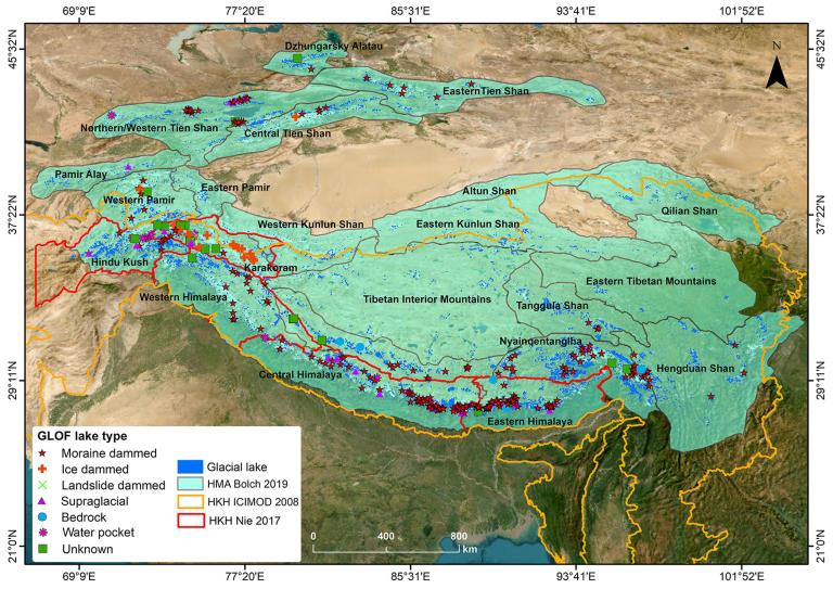
The China-Nepal flood was caused by the sudden draining of a ‘supraglacial’ lake that started forming as a small pond in end of December 2024 and grew significantly in June 2025, according to the International Centre for Integrated Mountain Development (ICIMOD), which is based in the Nepalese capital Kathmandu and is supporting WMO and other partners during the ongoing International Year of Glaciers’ Preservation.
In a press statement, ICIMOD scientists expressed shock at the increased frequency of glacial origin hazards.
- In the 2000s experts would anticipate a glacial origin flood to hit the Hindu Kush Himalaya region once every 5 to 10 years.
- In two months - May and June 2025 alone saw three glacial origin floods hit the region, in Nepal (Limi), in Afghanistan (Andorab valley) and Pakistan (Chitral, Hunza).
- On 7 July, there was not just one, but two glacial origin floods strike Nepal: in Rasuwa, and in Upper Mustang.
- A three-fold increase in GLOF risk across HKH is projected by the end of the 21st century.
Supraglacial lakes form on the surface of glaciers, particularly in debris-covered areas. They are highly dynamic, often beginning as small meltwater ponds that gradually expand and sometimes merge to form larger supraglacial lakes. The detection of these lakes largely depends on the spatial resolution of satellite imagery.
Temperature rise is known to play a key role in the increasing frequency of glacial origin floods.
WMO is working to increase global awareness of the short-term hazards of glacier melt this year during the International Year of the Glaciers’ Preservation , as well as to strengthen observations and monitoring through its Global Cryosphere Watch Programme.
Socioeconomic impacts
Flash floods are not new, but their frequency and intensity are increasing in many regions due to rapid urbanization, land-use change, and a changing climate. A warmer atmosphere holds more moisture and so this means that extreme rainfall events are becoming more frequent.
Flash floods alone account for nearly 85% of all flooding-related fatalities and result in economic losses exceeding $50 billion annually. A global study by the World Bank estimates that 1.81 billion people (23% of the world population) are directly exposed to 1-in-100-year floods, with 89% of them residing in low- and middle-income countries.
Recent catastrophic floods highlight the urgent necessity for improved forecasting and warning systems:
- 2020 South Asian Floods: Affected over six countries, causing 6,511 fatalities and US$ 105 billion in damages.
- 2022 Pakistan Floods: 1,700+ casualties, 33 million people affected, with estimated losses of US$ 40 billion.
- 2024 Europe, Middle East and Africa Floods: Resulted in US$ 36 billion in economic damages.
WMO Action
WMO supports countries in predicting flash floods through the Flash Flood Guidance System (FFGS) under Flood Forecasting Initiative (FFI), a real-time forecasting and early warning platform used in over 70 countries.
This system integrates satellite precipitation, radar, and high-resolution numerical weather models to support forecasters in identifying local flash flood threats. The operational backbone includes a network of regional centres and national services trained to interpret and act on the guidance, often hours before rainfall-triggered flooding begins.
WMO and partners of Flash Flood Guidance System with Global Coverage are transitioning FFGS into a globally governed, Member-led system, and working towards its sustainability and interoperability to ensure live saving flash flood warnings and products are integrated into the Multi-Hazard Early Warning System framework of WMO Members.
Beyond the tools themselves, WMO plays a convening role by building national capacity, certifying hundreds of experts under a Flash Flood Forecasting Competency Framework, and facilitating real-time coordination between forecasting agencies and disaster managers.