From JCOMMOPS to OceanOPS: supporting oceanography and marine meteorology in-situ observations
- Author(s):
- Mathieu Belbéoch and Emanuela Rusciano, WMO-IOC OceanOPS

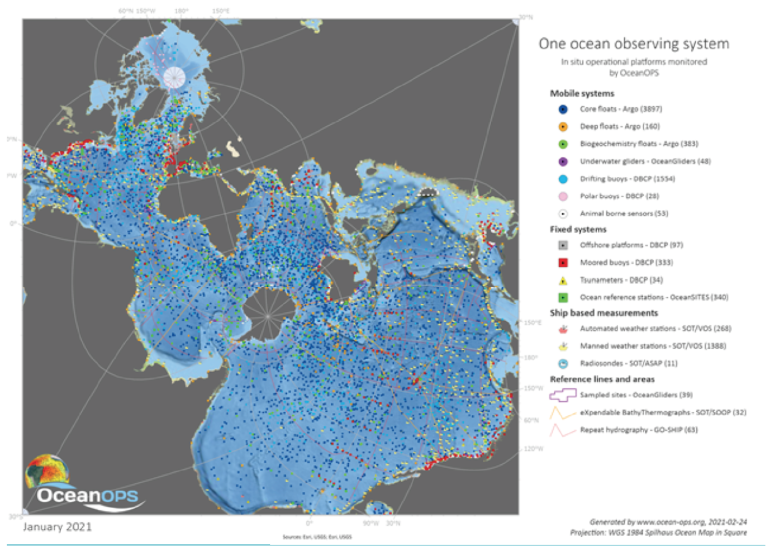
Eighty-six countries are involved in ocean observations with about 10 000 in situ ocean observing platforms and 170 satellites continuously monitoring the global ocean and atmosphere. The analyses, forecasts and products based on ocean observations are the bedrock of decisions across a swath of socio-economic sectors, especially in marine transportation, coastal communities, climate, agriculture and ocean health. Society's need for ocean information is increasing. In response, the Global Ocean Observing System (GOOS) is gaining in complexity, scope and coverage. Strong coordination is required within and amongst communities of observers from around the world to ensure delivery and cost efficiency from observations through to data management systems and information services.
In 1999, the World Meteorological Congress and the IOC/UNESCO Assembly adopted identical resolutions to establish the Joint WMO-IOC Technical Commission for Oceanography and Marine Meteorology (JCOMM). In turn, the first JCOMM session in 2001 established the Observing Platform Support Centre, known as JCOMMOPS.
Initially, JCOMMOPS built on the coordination facilities provided by the Data Buoy Cooperation Panel since the 1980s and the Ship Observations Team. It later also encompassed the revolutionary Argo profiling float programme, a key outcome of the OceanObs’09 conference. Synergy was realized between these three global marine observational programmes, which assists those in charge of implementing National observing components, through an integrated and international approach.

|
From 2001 to 2015, JCOMMOPS Centre was located in Toulouse (France), hosted by the CLS company, to interact closely with users of the Argos telecommunication system. There, it benefitted both from an operational infrastructure and access to a large raw data hub. The Centre operated initially with two technical coordinators then it grew gradually to support more sustained ocean observing systems, including the OceanSITES, GO-SHIP, OceanGliders, GLOSS and some emerging networks of the JCOMM/ GOOS Observations Coordination Group (OCG) such as the animal-based measurements (AniBOS).
The Centre developed a number of innovative services for real-time monitoring of the global networks’ performance and to assist implementers on a day-to-day basis, including in their operations at sea. The small JCOMMOPS team pioneered the web and Geographic Information System (GIS) technologies to track the ocean observing networks and offer a useful toolbox to scientists, program managers and to the GOOS/JCOMM governance.
The team opportunistically chartered a 20-metre sailing ship, Lady Amber, to assist Argo and Data Buoy Cooperation Panel (DBCP) implementers in filling gaps in the global arrays and demonstrate that low cost and low footprint solutions could find their place amongst the fleet of merchant and research vessels. The vessel did an equivalent of two circumnavigations, in the South Atlantic and Indian Ocean, seeding close to hundred instruments. This success story led to the establishment of a ship coordinator at JCOMMOPS to support the Ship Observations Team (SOT) and the Global Ocean Ship-based Hydrographic Investigations Program (GO-SHIP) and to act on all cross networks ship issues, including with civil society, non-governmental organizations (NGOs), sailing explorers and races.
In 2015, the Centre and staff moved to Brest (France), within the Institut Français de Recherche pour l'Exploitation de la Mer (Ifremer), to be closer to implementers in a worldwide ocean pole and with strong support from regional authorities. Its information system remained in Toulouse in the operational CLS cloud, with a 5-staff team in the Brest office. After years of preparation, a full revamp of the original information system and web-based applications was undertaken in 2015. It integrated the monitoring dashboard for GOOS and provided network specific tools and indicators, all fueled by a growing diversity of metadata and real-time pulses from the platforms.
Ocean Observing System Report Card
The annual publication since 2017 of the Ocean Observing System Report Card is a major achievement for the Observations Coordination Group and the Network experts. The publication communicates on the societal values of the observing system and encourage international collaboration, new partners, Members and Member States to join the challenge of building an integrated, sustained, innovative, globally implemented observing system that meets the growing demand for ocean services and science. It also helps the networks to raise their standards to meet integrated goals.
OceanOPS
In 2018, an external review of JCOMMOPS was conducted by the Observations Coordination Group to help the Centre and its stakeholders to better capitalize on its uniqueness and strengths and to identify issues, opportunities and challenges. The Review provided a tabulation of both strategic and operational actions for consideration and underlined the need for a five-year strategic plan that responds to key drivers and engages the JCOMMOPS stakeholder base. Therefore, JCOMMOPS started gathering perspectives and recommendations from stakeholders in 2019 in order to develop the strategic plan. The WMO Governance Reform, which was ongoing at the time, raised the ocean agenda and injected momentum into the JCOMMOPS process. In 2020, the five-year strategic plan was released. The WMO Governance Reform having disbanded JCOMM to create the Joint WMO-IOC Collaborative Board, the opportunity was taken to rebrand JCOMMOPS into OceanOPS.
OceanOPS supports efficient observing system operations to ensure the transmission and timely exchange of high-quality metadata, and assists with the provision of free and unrestricted data delivery to all users. The OceanOPS strategy is based on key goals, including: monitoring for the improvement of the global observing system performance, leading metadata standardization and integration, supporting and enhancing its operations, enabling new data streams and networks, and shaping the OceanOPS infrastructure for the future.
OceanOPS will develop tools and metrics to analyze the observing networks and system trends and report back to stakeholders to encourage performance improvement and cost efficiency. A core activity will be the harmonization of metadata for each observing network, individually and across the ocean observing system collectively. This will vastly increase data usability and global monitoring capacity. OceanOPS will maintain network specific services critical to ocean observing systems implementation, such as the IOC-UNESCO warning and notification system for floats approaching Coastal States waters. OceanOPS also has responsibility for allocating unique WMO identifiers to all met-ocean platforms and for providing integrated ocean metadata to the WMO OSCAR system. The WMO Governance Reform placed OceanOPS within the larger Earth System monitoring approach to develop synergies with cryosphere and hydrology.
OceanOPS believes there is a great potential to develop collaboration with third parties – civil society and the private sector – to contribute to the GOOS. The recent Vendée Globe Race offers a great example: ten skippers deployed autonomous instruments and carried out met-ocean observations during the race (see Vendée Globe Race Skippers go global with ocean observing!). OceanOPS has proposed a project for UN Decade of Ocean Science for Sustainable Development to frame these contributions and find solutions to distribute these datasets. Pilot projects are underway to develop an international data exchange service for non-institutional data, including with the WIS 2.0.
Challenges ahead
Over the past 20 years, OceanOPS has provided essential services, monitoring, coordinating and integrating ocean data and metadata. Based on its historical experience at the heart of the observing systems, OceanOPS has also identified a number of challenges that GOOS will have to overcome to build a globally integrated, sustainable and fully implemented observing system. Some are geographical: the opportunities to deploy autonomous instruments in the southern ocean are rare and the large majority of funding countries are in the North. While others are political: it is difficult to gain access to coastal states’ waters to complete the implementation of the GOOS. GOOS needs to reduce its fragmentation through an integrated and dimensioned design and an efficient governance. An unprecedented communication effort is needed to demonstrate its societal value to Member States to boost their support.
OceanOPS represents a core element of GOOS, essential to delivery, efficiency, insight and management of the observing system enterprise. It will work to address these challenges with the larger GOOS community.

