Region V: South-West Pacific

The South-West Pacific Region is a vast area that includes part of Southeast Asia, Australia, New Zealand and the Pacific, encompassing 24 WMO Members that fall within the scope of the WMO Regional Office for Asia and the South-West Pacific. WMO Members in the Pacific sub-region are further supported by the Representative Office for the South-West Pacific (SWP). The region covers various climate zones and is prone to a wide array of climate and weather-related impacts, from heatwaves and droughts to cyclones and floods. Southeast Asia's climate is largely shaped by monsoons and trade winds, while the Pacific is influenced by La Niña and El Niño cycles. The region is also part of the seismically active Pacific Rim.
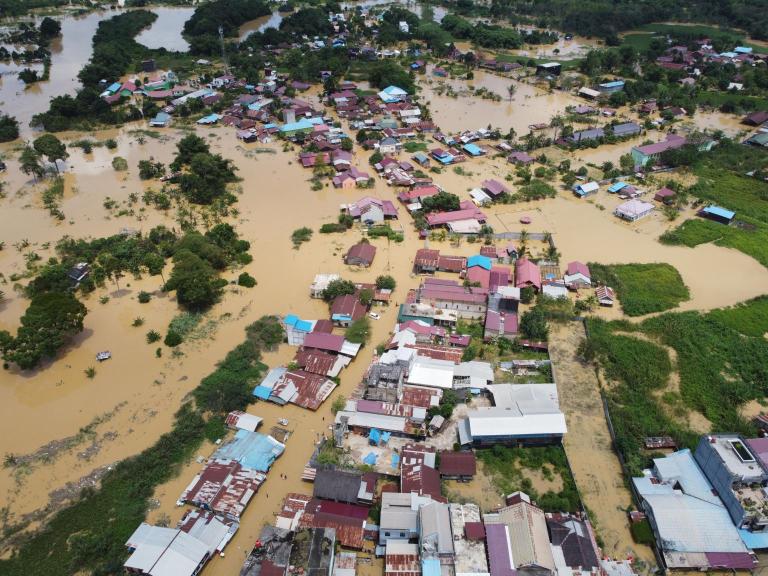
An aerial view of a flooded village.
Aerial view of Situation Flood in sangatta city, east kutai, east Kalimantan, Indonesia on 21 March 2022.
Adobe Stock

Over the past 50 years, the region has suffered 1,493 disasters, causing 66,951 deaths and $185.8 billion in economic losses. Tropical cyclones are the leading cause of these fatalities. The Southeast Asia sub-region includes countries like Malaysia and Indonesia, while the Pacific sub-region consists of Australia, New Zealand, and 14 Small Island Developing States. These islands are particularly vulnerable due to their low capacity for meteorological services. 

 Warming oceans and rising sea levels exacerbate these risks, especially for low-lying islands and coastal populations. To address these challenges, WMO collaborates with partners like the United Nations Office for Disaster Risk Reduction (UNDRR), the International Telecommunication Union (ITU), the International Federation of Red Cross and Red Crescent Societies (IFRC) as well as the UN Economic and Social Commission for Asia and the Pacific (ESCAP) to enhance Members’ early warning systems. Regional climate reports backed by scientific and socioeconomic data are aiding in policy formulation to build resilience against the escalating impacts of climate change. 

Projects in the region

Weather and Climate Early Warning System for Papua New Guinea

The Weather and Climate Early Warning System for Papua New Guinea project provides improved drought monitoring and early warning systems that can foster better decision making for the following sectors: agriculture, disaster management, energy and infrastructure. Other hazards related to droughts such as frost and bush fires would also be indirectly addressed.   The project creates end-to-end EWS focused on reducing drought impacts, while at the same time leveraging and providing a foundation for EWS focused on other hazards, and specifically flooding. The project address improved weather observations, climate data management of historical data for the monitoring of drought, climate data rescue, state-of-the-art seasonal forecasting coupled with monitoring and advisories for drought, and a more efficient distribution of alerts and information suitable for decision making at national and local level.    The focus is on building the capacity of the National Meteorological Service and strengthening its cooperation with key sectoral ministries, departments and other stakeholders working in the above areas to put in place complete systems that deliver warnings and relevant information to end-users. Enhancement of these basic capabilities is complemented with support for integration of early warnings into national processes. The project bring together technical expertise from cooperating institutions to ensure access to relevant data, products, tools, training, and equipment.  The selected sectors addressed by the project provide showcases for development of additional services subsequently. Several additional on-going or planned projects which the current project complements are identified below. 

Coastal Inundation Forecasting Demonstration Project Fiji (CIFDP-F) : Development of an Integrated Coastal Inundation Forecasting System in Fiji

The CIFDP- F is facilitating the development of efficient forecasting and warning systems for coastal inundation based on robust science and observations, along vulnerable coastal areas in Fiji. In doing so, the CIFDP-F will integrate cross-cutting scientific models into an open forecasting environment for the purpose of improving/ expanding/ developing the forecasting and warning systems for storm surges, hydrological response to heavy rainfall and Tropical Cyclone landfall on coastal areas, and other phenomena causing coastal inundation. Beneficiary groups  are mainly coastal communities in Fiji in the immediate term, through the improved performance of national institutions responsible for coastal disaster forecasting, warning, and climate adaptation planning. Every year, populations in coastal zones are impacted by coastal inundation caused by waves, including long period swell, storm surges and hydrological inundation, resulting in loss of life and damage to property. The results of this project will provide critical information to improve forecasting, warning, and evacuation planning in coastal zones.            The beneficiary sectors will include the coastal residents (end users) in agriculture, fishery, tourism and other industries, disaster managers in central and regional governments (intermediary users). In particular, improved forecasting services will serve greatly to ensure safe operation of tourism business, which is a major source of Fiji’s income. The project is divided into phases to be implemented within the period 2016 to 2020 and a total budget of USD 1.2 million, generously provided by the Korea Meteorological Administration.

WMO Offices in the region

WMO Representative Office for the South-West Pacific (SWP)

SPREP Campus, Vailima 

Apia, Samoa 

Email: rap@wmo.int 

WMO Regional Office for Asia and the South-West Pacific

36 Kim Chuan Road, 

Singapore 537054 

Singapore 

Email: rap@wmo.int