Ocean heat and sea-level rise threaten communities in the South-West Pacific
Unprecedented Ocean warming engulfed the South-West Pacific in 2024, harming ecosystems and economies, according to a new report from the World Meteorological Organization (WMO), which highlighted how sea level rise is threatening islands in a region where more than half the population live close to the coast.
- 2024 was hottest year on record in SW Pacific
- Sea surface temperatures were highest on record
- Marine heatwaves stretched for 40 million km²
- Sea level rise threatens entire islands
- Tropical glaciers in Indonesia head for extinction
- Philippines faced unprecedented tropical cyclones

The State of the Climate in the South-West Pacific 2024 Report said that sea-surface temperatures were the highest on record, and ocean heat content was at near-record levels in 2024. Nearly 40 million km² (15.4 million square miles) was affected by marine heatwaves. This is more than 10 % of the global ocean surface area, almost the size of the Asian continent or four times the size of Europe and of the United States of America.
On land, extreme heat and rainfall caused deadly and devastating impacts. A record-break streak of tropical cyclones hit the Philippines, whilst the last remaining tropical glacier in Indonesia’s New Guinea headed closer to extinction.
“2024 was the warmest year on record in the South-West Pacific region. Ocean heat and acidification combined to inflict long-lasting damage to marine ecosystems and economies. Sea-level rise is an existential threat to entire island nations. It is increasingly evident that we are fast running out of time to turn the tide,” said WMO Secretary-General Prof Celeste Saulo.
The State of the Climate in the South-West Pacific is one of a series of annual WMO global and regional reports which seek to inform decision-making for national and regional adaptation strategies and to build resilience in a changing climate. It was released to coincide with the Global Platform on Disaster Risk Reduction 2025 in Geneva and ahead of the 2025 UN Ocean Conference.
The report contains some good news. It includes a case study showing how strengthened early warning systems and Anticipatory Action in the Philippines enabled communities to prepare and respond to the back-to-back typhoons in 2024. This helped to protect lives and livelihoods and ensure dignified, timely support for vulnerable communities. This exemplifies the value of the Early Warnings for All (EW4All) initiative, which is one of WMO’s top strategic priorities.
A separate case study of Fiji’s Serua Island highlights the cultural and spiritual challenges of relocating displaced communities, given the deep ancestral ties to the land. It is estimated that each year, at least 50,000 Pacific islanders face the risk of displacement due to the adverse effects of climate change.
Key Messages
Temperature
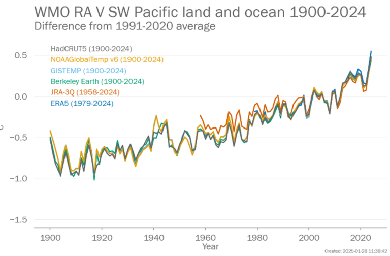
2024 was the warmest year on record in the South-West Pacific region, at approximately 0.48 °C above the 1991–2020 average. This was associated with the continued influence from the 2023/2024 El Niño event. Many countries recorded their warmest year, based on their national datasets.
Extreme heat affected large parts of the region in 2024, with record-breaking temperatures in Australia and the Philippines, posing serious risks to public health, livelihoods, and ecosystems.

Precipitation and storms
The southern coast of Australia, northern New Zealand, and many Pacific Islands all suffered precipitation deficits, whilst parts of Malaysia, Indonesia, northern Philippines, northern Australia, eastern Papua New Guinea, Solomon Islands, and southern New Zealand saw above average rainfall in 2024.
Extreme rainfall and flooding caused deadly and destructive impacts across the region, with major events in Australia, New Zealand, Fiji, Malaysia, Indonesia, and the Philippines disrupting communities, infrastructure, and economies.
The late 2024 tropical cyclone season in the Philippines was unprecedented, with 12 storms during September to November — more than double the average. Across the entire sequence, over 13 million people were impacted in 17 of the country’s 18 regions, with more than 1.4 million displaced.
Cryosphere
Snow and ice are rare in most, but not all, of the South-West Pacific. There are glaciers in the mountains of New Zealand and on the highest peaks of the western part of the island of New Guinea.
In Indonesia, glacier ice loss continued rapidly in 2024, with the total ice area in the western part of New Guinea declining by 30-50% since 2022, according to satellite estimates. If this rate persists, total ice loss is expected in 2026 or very soon thereafter.
Ocean
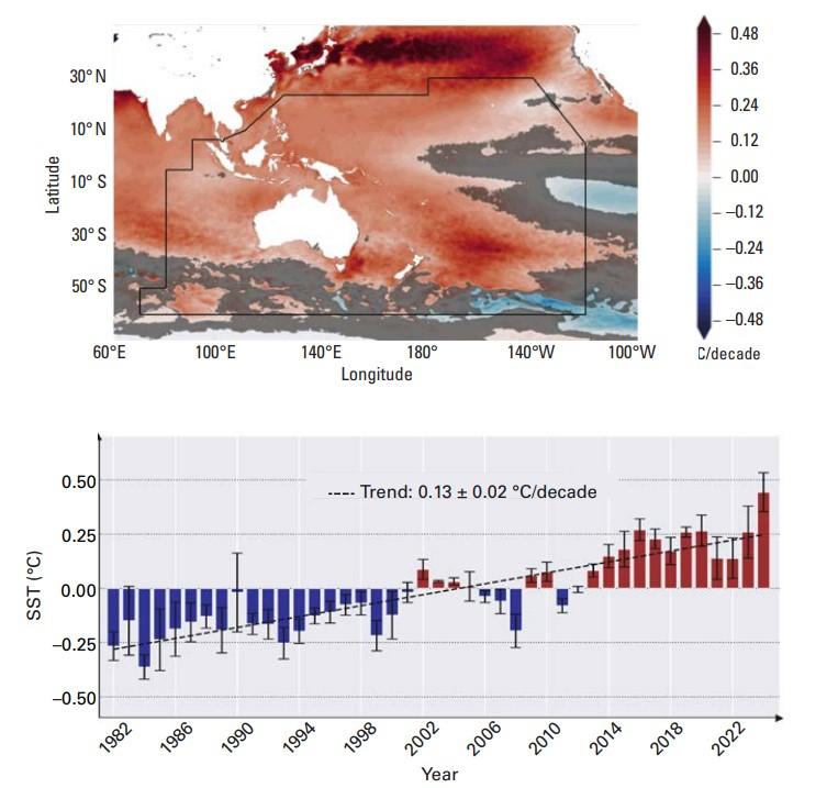
The annual average sea surface temperature in 2024 was the highest in the time series starting in the early 1980s.
In 2024, ocean heat content for the South-West Pacific tied with 2021 and 2023 as joint second highest, behind the record in 2022. Areas of strongest ocean warming over the past five decades include the Tasman Sea, the Solomon Sea, and most of the areas around the Pacific Small Island States.
Ocean warming contributes to sea-level rise and alters ocean currents. It also indirectly alters storm tracks, increases ocean stratification, and can lead to changes in marine ecosystems.
Most of the ocean area of the South-West Pacific region was affected by marine heatwaves of strong, severe, or extreme intensity during 2024. During the months January, April, May, and June 2024, nearly 40 million km² of the region's ocean was impacted, marking a record high since records began in 1993.
Ocean acidification, together with ocean warming and deoxygenation is affecting marine ecosystems, habitats and biodiversity. The entire ocean area of the South-West Pacific region is experiencing ocean acidification.

Sea level
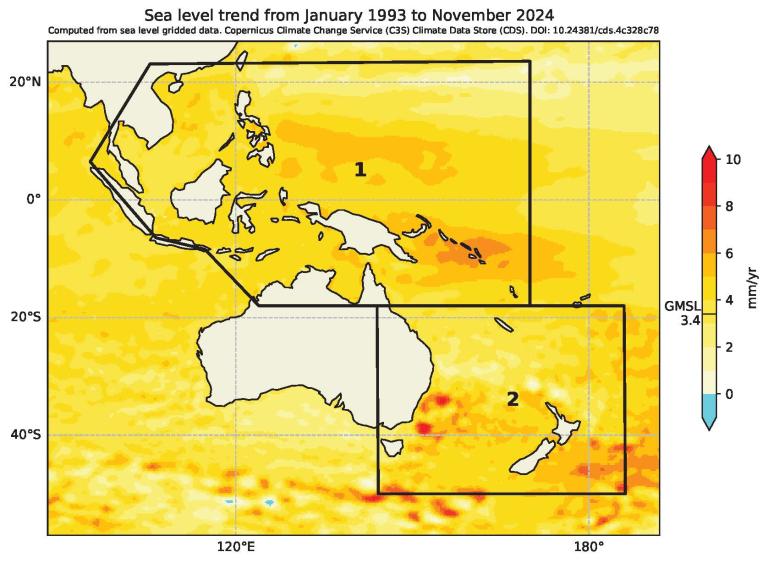
Across the region, sea level exceeds the global average, threatening Pacific islands where more than half the population live within 500 metres of the coast. Communities are facing difficult decisions about staying in high-risk areas or relocating to secure their futures.
For instance, over the past two decades, coastal erosion and flooding have severely damaged the village of Serua Island in Fiji, with the seawall being destroyed, homes being submerged, and seawater killing food crops and washing away fertile soil. On two separate occasions, the island experienced such extreme flooding that it was possible to cross the entire island by boat without encountering land.
Villagers are running out of adaptation options, with building of seawalls, plantation of mangroves, and improvement of drainage systems no longer being viable. The Government of Fiji has offered support for the islanders to relocate, but many are choosing to stay because of the concept of “vanua”, which translates literally to “land”, embodying the profound connection between the Indigenous communities and their ancestral lands.

Anticipatory Action
The collective impact of the record-breaking tropical cyclones in the Philippines in 2024 was devastating. Early estimates placed damages to infrastructure, homes, and agriculture at US$ 430 million. However, loss of life was limited thanks to impact-based early warnings and anticipatory action, which involved the mobilization of the Food and Agriculture Organization’s Anticipatory Action teams. They distributed cash transfers and facilitated the evacuation of fishing boats to safer grounds ahead of the typhoons.
Building resilience is a priority for the Philippines National Adaptation Plan. While the frequency of tropical cyclones is expected to decrease, their intensity will significantly increase, resulting in severe damage to infrastructure, agriculture and coastal areas, affecting millions of Filipinos.
Notes to Editors
The State of the Climate in the South-West Pacific report is based on input from National Meteorological and Hydrological Services (NMHSs) and a wide network of experts from the WMO community and international and regional partners. WMO wishes to thank all contributors.
The World Meteorological Organization is the United Nations System’s authoritative voice on Weather, Climate and Water.
For further information, please contact:
- Clare Nullis WMO media officer cnullis@wmo.int +41 79 709 13 97
- WMO Strategic Communication Office Media Contact media@wmo.int
- Region:
- Region V: South-West Pacific

